The Last 20%: Why Route Planning for Adventure PR Events and Photo/Video Shoots Requires Real-World Recon
Planning an adventure motorcycle ride has never been easier, yet in many ways it has also become more complicated. Modern technology has given riders an incredible set of tools for researching trails, terrain, and destinations, as well as logistics and resources. Today there are mapping platforms with satellite imagery, GPS route builders, trail databases, ride reports, and countless photos and videos posted by other riders who have already traveled the same areas. With enough time behind a computer, a rider can trace nearly every mile of a route, examine elevation profiles, and read detailed accounts of how others experienced the trail.
Technology also makes it remarkably easy to plan the logistical side of travel. With a few clicks you can identify fuel stations along a route, find restaurants and grocery stores, reserve hotels, and even locate nearby powersports dealerships or service centers in case you need additional accessories, or if a machine needs parts or repair. The modern rider has more information available than any generation before, but not everything. Even with all of these tools available, there is a simple reality that anyone who spends time exploring eventually learns. From a computer or a remote location, you can only gather about 80% of the information about a place; that final 20% is something you only discover once you are actually there.
For many adventure travelers, that final 20% is actually part of the excitement. If the major elements are taken care of such as the destination, the fuel stops, food options, and a place to sleep, the rest of the experience becomes part of the adventure itself. Adventure riding has always been about curiosity and exploration, and leaving some room for the unknown is often what makes a trip memorable.
However, the equation changes when you are planning something more structured such as a media event, a professional photoshoot, or a brand hosted ride. In those situations, the unknown can quickly become a problem. When you are responsible for a group of riders, photographers, support staff, and clients, you cannot rely on guesswork or assumptions. That is why pre riding a route and physically visiting locations becomes such an important part of the planning process. There is simply no substitute for putting tires on the ground and experiencing a place firsthand before bringing a larger group into that environment. Even if you are familiar with a location, you still need to analyze it from the perspective of your group size, expectations, and skill level.
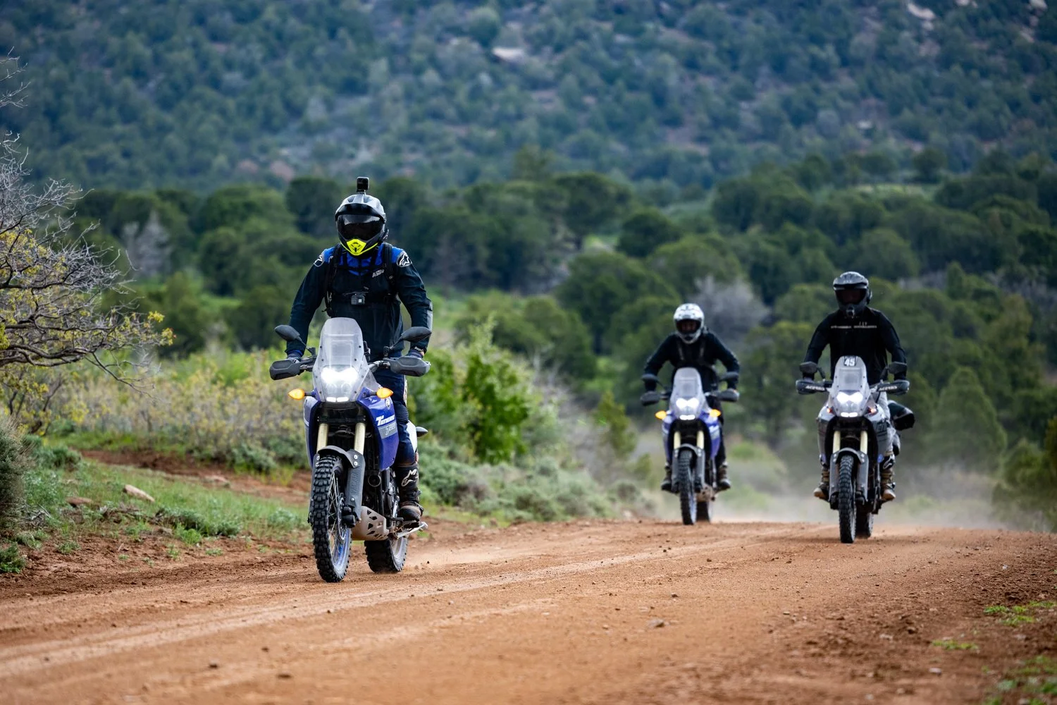
One of the first things that becomes clear during a pre-ride is the true nature of the trails and roads themselves. Mapping software can show the location of a road and satellite imagery can provide a rough visual of the terrain; neither of these tools can truly explain what it feels like to ride the surface. A road that appears smooth and manageable on the map could easily turn out to be rocky and technical once you arrive. Environmental hazards such as mud or dust, loose sand, embedded rock, washboard sections, or rutted slopes can completely change the character of a ride. In addition, a trail’s evolution over time including weather events and trail maintenance can drastically change the experience year-over-year. These differences can dramatically affect the difficulty level of a road or trail, and even just short sections could make the overall route impassable, especially when riding with a group that includes riders of varying skill levels.
Surface conditions also influence equipment decisions. Tire choice can determine if riders feel confident and in control or spend the entire day struggling, or on the verge of a crash. In addition, suspension may need to be adjusted or customized for each rider, or specific features or accessories may need to be promoted. In many cases riders may want to bring specific protective equipment based on the terrain they expect to encounter. These are the kinds of details that rarely become clear from a map alone.
Environmental and weather conditions are additional factors that only truly reveal themselves when you visit a location. In mountain environments the temperature can change dramatically throughout the day, especially when the route includes significant elevation gain. A ride that begins in warm sunshine at lower elevations may climb into freezing temperatures on a high pass early in the morning. Afternoon thunderstorms can transform a dry dirt road into slick mud within minutes, which changes not only the riding difficulty but also the overall safety of the route. Understanding how these conditions develop in a specific location at specific times of the year, helps everyone prepare with the correct clothing, equipment, and additional resources.
Beyond the trails themselves there is another layer of planning that every rider must consider, which is the basic human needs that support any multi-day trip. Motorcycles need fuel, riders need food, and everyone needs a place to sleep at the end of the day. Mapping software can quickly identify these locations, but when you begin organizing rides for larger groups the logistics become much more complex.
Restaurants are a good example of how simple planning can quickly become complicated. A location that works perfectly for a few riders stopping in for lunch may struggle when 20-30 people arrive at the same time. Seating capacity, kitchen speed, and staff availability all influence whether a large group can be served efficiently. When riders are traveling on a schedule for an event or photoshoot, delays at a meal stop can ripple through the rest of the day. Taking the time to visit these locations ahead of time allows planners to understand how the venue operates and whether it is capable of accommodating your group.
Parking is another important detail that often goes unnoticed until you arrive. A group of adventure motorcycles takes up a surprising amount of space, especially if the group arrives with additional support vehicles such as trucks and trailers. What appears to be a spacious parking lot on satellite imagery may quickly feel cramped with other customer vehicles in addition to your group all arriving around the same time.
There is also an intangible factor that becomes obvious only when visiting a place in person, something colloquially known as “the vibe check”. Some towns and businesses genuinely enjoy hosting riders, and motorcycles parked outside can create a lively atmosphere and often bring enthusiastic customers who appreciate the stop along their journey. Other locations may see a large group of motorcycles as disruptive or unwelcome. While this is certainly subjective, the atmosphere of a restaurant, hotel, or small town can dramatically influence the overall experience of a ride. Finding places that embrace riders often becomes one of the highlights of a trip.
Finally there are the truly unpredictable elements that only reveal themselves once you stand in a location and observe the details around you. These are the small issues that no mapping tool or satellite image will ever fully capture. Perhaps a parking lot looks ideal for a support vehicle or equipment truck, but the entrance has a small drainage dip designed to move water off the road. That dip might be perfectly manageable for cars and motorcycles, yet it could prevent a large truck from entering the area. Something as small as a tight turn, or a low overhang, or a water crossing may prevent riders or support vehicles from proceeding along.
In remote riding areas there are also safety considerations that deserve careful attention. Beautiful terrain often comes with the tradeoff of isolation. Some routes may be located hours away from the nearest hospital or emergency services, which changes how an event or group ride must be managed. Beyond just the risk of a crash, riders or staff may have medical conditions that may require attention during an event, and planners need to consider the possibility of injuries or health emergencies even if the riding itself is relatively low-risk. Allergies, heat exhaustion, altitude sickness, and dehydration are all realistic possibilities when people spend long days traveling through remote landscapes.
Wildlife, insects, and changing weather patterns can also influence the experience. In certain regions riders may encounter insects and other animals that require caution such as snakes, deer and elk, and more. In mountainous terrain sudden storms or falling temperatures can dramatically change conditions. Understanding how to respond to these scenarios requires more than simply knowing the route; it requires familiarity with the environment itself, and an extra attention to detail.
All of these factors are a major part of what makes adventure riding so appealing in the first place. Exploring new landscapes and discovering the unexpected is at the heart of the experience. When riders are traveling on their own personal trips, leaving space for the unknown is often what makes the journey memorable. However, when planning an organized ride, media event, or professional production, that unknown has to be reduced as much as possible.
So go visit the locations, spend a couple days and do what you need to create a seamless experience. Technology can provide most of the information needed to design a route and build a framework for the journey, yet that final twenty percent of knowledge only comes from being there. It comes from flying into the local airport, standing in the parking lots, eating at the restaurants, walking through the hotels, speaking with the people, and of course riding the trails.